News
Durham City Council must vote against the Perry Farms proposal
ACTION ALERT, Action Alerts, Environmental, Neuse River Watershed, Sound Rivers, Stormwater Issues, Stormwater Runoff, Water Quality
Posted on October 30th, 2023
Where Martin Branch and Lick Creek meet in Durham.
Send an email to Durham City Council asking them to vote “No!” to Perry Farms rezoning!
On Nov. 6, the Durham City Council will vote whether to approve rezoning for a proposed development in southeast Durham.
The same development was turned down by council in the summer of 2022. The only change in the proposal is a different developer is proposing it.
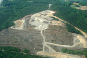
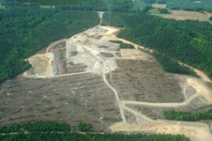
The project proposes building up to 665 townhomes on 280-plus acres of high-quality forested land in an area where rampant development has already put significant pressure on the impaired Lick Creek watershed and ecosystem. The property is also part of the Middle Lick Creek Bottomlands Natural Area, which is listed on the North Carolina Natural Heritage Registry.
The Perry Farms project is an example of irresponsible development in an already heavily impacted location. Learn why below.
Perry Farms Rezoning Proposal
- The project would convert 280-plus acres of high-quality forested land along Lick Creek and Kemp Road in southeast Durham to up to 665 townhomes.
- The proposal is located on the north and south side of Lick Creek, which is within the environmentally fragile and more stringently protected Falls Lake watershed.
- The property is part of the Middle Lick Creek Bottomlands Natural Area, listed on the North Carolina Natural Heritage Registry.
- The building and parking footprint in the development plan would impact a large part of the southern portion of the mapped Natural Heritage Area. Other impacted areas include functioning wetlands, floodplains and steep slopes, all of which pose significant environmental challenges if developed.
Reasons why the proposed rezoning should not be approved
- Section 13.1 of Durham’s Unified Development Ordinance states, “to the maximum extent possible, subdivisions shall be designed to … protect habitats of rare or unusual plants or wildlife as documented in the established Durham Inventory, the State Natural Heritage Listing, or the National Register of Historic Places.” The Middle Lick Creek Bottomlands Natural Area contains mature, hardwood forest and rare plant species, including the significantly rare Douglass’s Bittercress.
- NC Natural Heritage Program areas are protected through a series of standards, including special use permits and conservation subdivision requirements. Conservation subdivision rules require 50% open space, of which 80% of the trees are preserved. The Perry Farms proposal offers to leave only 36% tree preservation.
- The NC Natural Heritage Program recommends 300-foot vegetated buffers on either side of aquatic natural areas (in this case, Lick Creek) and 100-foot riparian buffer for feeder creeks within natural areas (in this case, tributaries feeding Lick Creek). The Perry Farms developer is only offering 50-foot streamside buffers on several tributaries of Lick Creek.
- Durham has adopted new Sediment & Erosion Control regulations as a response to public outcry about sediment pollution from developments. Durham has no quality control measures in place to ensure that the new measures are working. An efficacy study must be conducted to demonstrate that new S&EC rules are working before approving more significant land-changing proposals in the area.
- The last Lick Creek Watershed Analysis (2006) stressed, “A key management strategy in preventing impacts to this largely undeveloped watershed is the protection of those lands that are most critical to water quality and aquatic habitat.” Durham has not followed these recommendations, and thousands of acres of land have been clear-cut to make way for developments, which has led to erosion, which has negatively impacted water quality (as stated in the 2006 analysis).
- In 2006, $97,000 of taxpayer money and an additional $539,000 of public grant money were invested in stream restoration efforts along Lick Creek. Today, the City of Durham is investing in a Southeast Durham Watershed Improvement Plan, to improve water quality and hydrology in Lick Creek. In the context of the significant damage from ongoing developments in the area, approving a massive development right alongside Lick Creek will undercut this planning process and those watershed investments.
Given the location of this proposal, and the broader picture of ongoing impacts to the Lick Creek watershed, and Falls Lake downstream, a developer should be required to offer more than the bare minimum of environmental protections in high value conservation areas, along federally listed impaired waterways like Lick Creek.
Durham council must do the right thing and promote responsible development by turning this project down — again.
Write your email to Durham City Council asking them to vote “No!” to Perry Farms rezoning!
The broader picture of the Lick Creek watershed
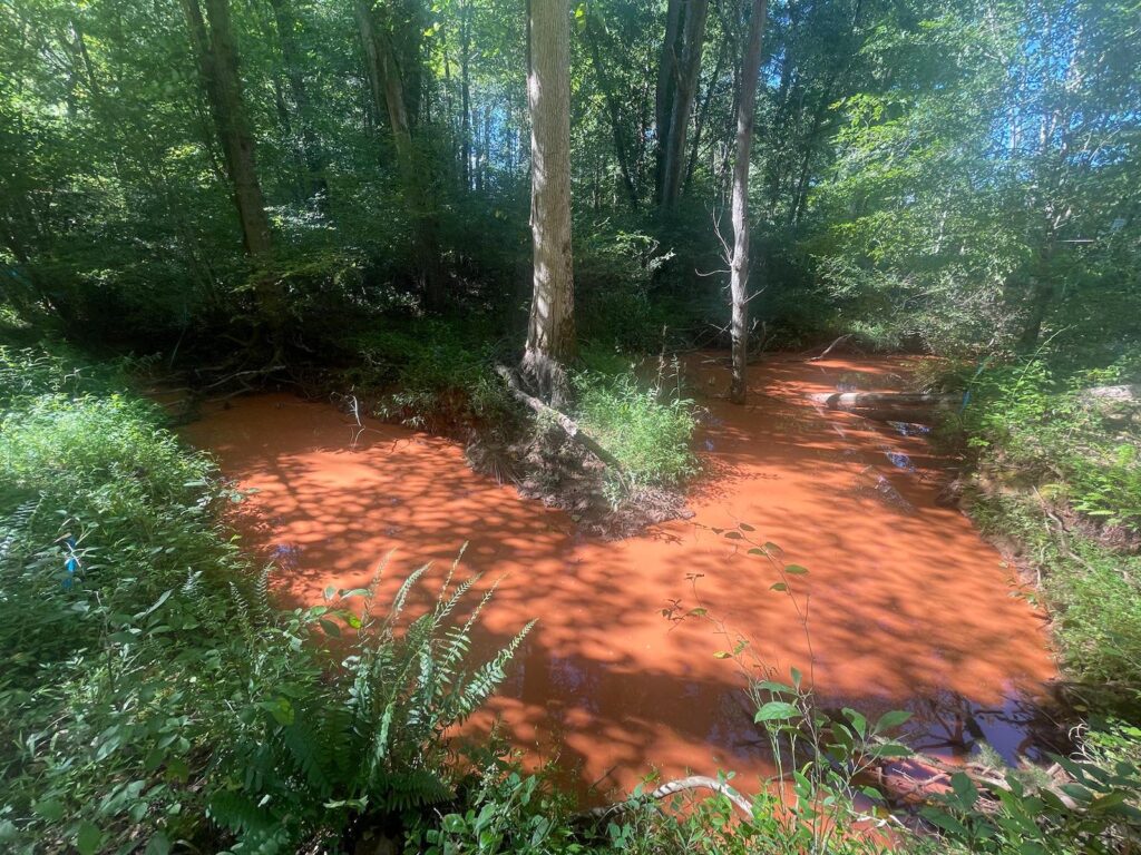
Since October of 2022, Sound Rivers has been actively documenting sediment pollution from ongoing land-clearing developments in the Lick Creek watershed.
The Lick Creek watershed lies within the Triassic basin, a geologic formation characterized by fine particulate soils. Triassic basin soils are poor-quality, predominantly clay material that erodes easily and takes a long time to settle when suspended in waterways. According to the 2009 Lick Creek Watershed Restoration Plan, “These Triassic streams are greatly impacted by the increased flows accompanying urban development because the sand and clay substrate material erodes easily.”
With the change in zoning from agricultural/rural to medium to low-density residential, the rapid development in the Lick Creek watershed and large residential projects on multi-year construction timelines are degrading the creek’s water quality due to increased sediment and pollutants in the runoff.
The creek has been listed on the NC 303(d) list as impaired since 2006 because it does not adequately support aquatic life due to excessive in-stream turbidity and exceedingly low levels of dissolved oxygen. One of the primary stressors contributing to impairment is sediment pollution.
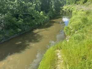
Over the past year, Sound Rivers has sampled Martin Branch, a Lick Creek tributary running adjacent to an active development site. On all sampling occasions, Martin Branch had turbidity levels (how much sediment is hanging, as opposed to settling in the water) exceeding the state’s standard of 50 NTU, reaching as high as 35 times the standard on one occasion. This extremely turbid water is emptying directly into the main stem of Lick Creek. For comparison, turbidity levels at a nearby tributary that does not run next to a land-clearing development were consistently near, or under, the state standard of 50NTU, and far below turbidity levels in impacted creeks.
Because turbidity in Martin Branch has far exceeded the state’s standard for at least 11 consecutive months, and is directly feeding into the main stem of Lick Creek, we can confidently assume that, at this point, severe damage has been done to Lick Creek’s aquatic habitat.
The chart shows a comparison of the turbidity in Lick Creek downstream and upstream with the Martin Branch confluence turbidity in the middle. This shows how Martin Branch almost always influences the downstream turbidity.

The turbidity levels at a nearby tributary (Rocky Branch) that does not run next to a land-clearing development were consistently near or under the state standard of 50NTU, and far below turbidity levels in impacted creeks.

Schematic adapted from “Turbidity: A Water Quality Measure”, Water Action Volunteers, Monitoring Factsheet Series, UW-Extension, Environmental Resources Center. This graph is a generic, un-calibrated impact assessment model based on Newcombe, C. P., and J. O. T. Jensen. 1996. Channel suspended sediment and fisheries: a synthesis for quantitative assessment of risk and impact. North American Journal of Fisheries Management. 16: 693-727.

Related News

‘Swim-terns’ on board for summer 2024
May 16th 2024
Riverkeeper responds to Swift Creek spill, CAFO violations
May 16th 2024

Riverkeeper goes Raleigh trash-trap scouting
May 16th 2024

Lick Creek: Durham Council to vote on another large development
May 16th 2024

Riverkeeper, trash traps get standing ovation
May 16th 2024

Neuse Trivia Night brings a crowd to Clouds Brewing
May 16th 2024

Dog Days an educational adventure
May 16th 2024
Moriah Energy Center Impacts
May 14th 2024